Weather Alert in Nebraska
Air Quality Alert issued August 1 at 12:23PM CDT by NWS Omaha/Valley NE
AREAS AFFECTED: Knox; Cedar; Thurston; Antelope; Pierce; Wayne; Boone; Madison; Stanton; Cuming; Burt; Platte; Colfax; Dodge; Washington; Butler; Saunders; Douglas; Sarpy; Seward; Lancaster; Cass; Otoe; Saline; Jefferson; Gage; Johnson; Nemaha; Pawnee; Richardson
DESCRIPTION: The following is transmitted in collaboration with the Nebraska Department of Health and Human Services and the Nebraska Department of Environment and Energy... WHAT...Air Quality Alert WHERE...Eastern and Central Nebraska WHEN... 08/01/2025 12:00 PM until 08/02/2025 5:00 PM POLLUTANT...PM 2.5 particulates AIR QUALITY INDEX...Moderate to Unhealthy ADDITIONAL DETAILS... An alert for possible Moderate (Air Quality Index yellow category) to Unhealthy AQI (Air Quality Index red category) due to smoke has been issued for the following Nebraska counties: Adams, Antelope, Blaine, Boone, Boyd, Brown, Buffalo, Burt, Butler, Cass, Cedar, Clay, Colfax, Cuming, Custer, Dakota, Dawson, Dixon, Dodge, Douglas, Fillmore, Franklin, Furnas, Gage, Garfield, Gosper, Greeley, Hall, Hamilton, Harlan, Holt, Howard, Jefferson, Johnson, Kearney, Keya Paha, Knox, Lancaster, Loup, Madison, Merrick, Nance, Nemaha, Nuckolls, Otoe, Pawnee, Phelps, Pierce, Platte, Polk, Richardson, Rock, Saline, Sarpy, Saunders, Seward, Sherman, Stanton, Thayer, Thurston, Valley, Washington, Wayne, Webster, Wheeler, and York, from August 01, 12:00 pm through August 02, 5:00 pm. During Moderate AQI (yellow category) conditions, those who are unusually sensitive to particle pollution may experience health effects. When conditions rise to the yellow category, those who are unusually sensitive are advised to consider shortening outdoor activities and reducing the intensity of these activities. Symptoms such as coughing or shortness of breath are signs to take it easier. During Unhealthy for Sensitive Groups (orange category) conditions, members of sensitive groups may experience health effects. Sensitive groups include people with heart or lung disease, older adults, and children. When conditions rise to the orange category, sensitive groups are advised to reduce prolonged or heavy exertion and avoid intense outdoor activities. During Unhealthy AQI (red category) conditions, some members of the general public may experience health effects and members of sensitive groups may experience more serious health effects. Sensitive groups include people with heart or lung disease, older adults, children and teens, and those who are active outdoors. When conditions rise to the red category, everyone is advised to avoid prolonged or heavy exertion and take more breaks; those in sensitive groups should also plan outdoor activities for morning hours when ozone levels are lower. Smoke from Canadian wildfires may affect the air quality in Nebraska. Smoke levels and wind directions are monitored by Nebraska and other states to predict when impacts to the air quality may occur. Information regarding wildfires and Impacts in Nebraska is available from the Nebraska Department of Water, Energy, and Environment (DWEE) at https://dee.nebraska.gov/wildfires-and- impacts-nebraska. Alerts are based on data available from weather forecasts, smoke plume modeling, satellite imagery, and from air quality monitors located in Omaha, Bellevue, Blair, Lincoln, Beatrice, Grand Island, and Scottsbluff. Advisories for smoke and air quality are issued for affected areas by the Nebraska Department of Health and Human Services (DHHS) and Department of Water, Energy, and Environment (DWEE) and posted on agency webpages and social media sites. By notifying the media and local health departments, alerts help citizens protect their health by informing them of days where outdoor activities should be reduced or avoided to minimize exposure to smoke.
INSTRUCTION: N/A
Want more detail? Get the Complete 7 Day and Night Detailed Forecast!
Current U.S. National Radar--Current
The Current National Weather Radar is shown below with a UTC Time (subtract 5 hours from UTC to get Eastern Time).

National Weather Forecast--Current
The Current National Weather Forecast and National Weather Map are shown below.

National Weather Forecast for Tomorrow
Tomorrow National Weather Forecast and Tomorrow National Weather Map are show below.

North America Water Vapor (Moisture)
This map shows recent moisture content over North America. Bright and colored areas show high moisture (ie, clouds); brown indicates very little moisture present; black indicates no moisture.

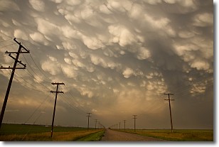
Weather Topic: What are Mammatus Clouds?
Home - Education - Cloud Types - Mammatus Clouds
 Next Topic: Nimbostratus Clouds
A mammatus cloud is a cloud with a unique feature which resembles
a web of pouches hanging along the base of the cloud.
In the United States, mammatus clouds tend to form in the warmer months, commonly
in the Midwest and eastern regions.
While they usually form at the bottom of a cumulonimbis cloud, they can also form
under altostratus, altocumulus, stratocumulus, and cirrus clouds. Mammatus clouds
warn that severe weather is close.
Next Topic: Nimbostratus Clouds
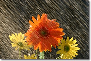
Weather Topic: What is Precipitation?
Home - Education - Precipitation - Precipitation
 Next Topic: Rain
Precipitation can refer to many different forms of water that
may fall from clouds. Precipitation occurs after a cloud has become saturated to
the point where its water particles are more dense than the air below the cloud.
In most cases, precipitation will reach the ground, but it is not uncommon for
precipitation to evaporate before it reaches the earth's surface.
When precipitation evaporates before it contacts the ground it is called Virga.
Graupel, hail, sleet, rain, drizzle, and snow are forms of precipitation, but fog
and mist are not considered precipitation because the water vapor which
constitutes them isn't dense enough to fall to the ground.
Next Topic: Rain
Current conditions powered by WeatherAPI.com


