Weather Alert in Montana
Special Weather Statement issued August 19 at 11:59PM MDT by NWS Great Falls MT
AREAS AFFECTED: Hill County; Western and Central Chouteau County; Bears Paw Mountains and Southern Blaine
DESCRIPTION: At 1158 PM MDT, the public reported gusty showers along a line extending from 10 miles southwest of Gildford to near Big Sandy to 26 miles southwest of St. Pierre to 12 miles northeast of Geraldine. Movement was northeast at 55 mph. HAZARD...Wind gusts of 50 to 55 mph. SOURCE...Widespread public reports of 50 to 55 mph wind gusts. IMPACT...Gusty winds could knock down tree limbs and blow around unsecured objects. Locations impacted include... Havre, Big Sandy, Azure, Parker School, Beaver Creek, Agency, St. Pierre, Gildford, Sangrey, Boneau, Box Elder, Hingham, Rocky Boy, Laredo, Kremlin, Judith Landing, and Iliad.
INSTRUCTION: If outdoors, consider seeking shelter inside a building. Wind gusts will pick up long before any rain falls, so seek shelter now! These storms may intensify, so be certain to monitor local radio stations and available television stations for additional information and possible warnings from the National Weather Service.
Want more detail? Get the Complete 7 Day and Night Detailed Forecast!
Current U.S. National Radar--Current
The Current National Weather Radar is shown below with a UTC Time (subtract 5 hours from UTC to get Eastern Time).

National Weather Forecast--Current
The Current National Weather Forecast and National Weather Map are shown below.

National Weather Forecast for Tomorrow
Tomorrow National Weather Forecast and Tomorrow National Weather Map are show below.

North America Water Vapor (Moisture)
This map shows recent moisture content over North America. Bright and colored areas show high moisture (ie, clouds); brown indicates very little moisture present; black indicates no moisture.

Weather Topic: What are Hole Punch Clouds?
Home - Education - Cloud Types - Hole Punch Clouds
 Next Topic: Mammatus Clouds
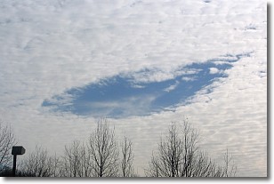
A hole punch cloud is an unusual occurrence when a disk-shaped
hole appears in a cirrostratus, cirrocumulus, or altocumulus cloud.
When part of the cloud forms ice crystals, water droplets in the surrounding area
of the cloud evaporate. The effect of this process produces a large elliptical
gap in the cloud. The hole punch cloud formation is rare, but it is not specific
to any geographic area.
Other names which have been used to describe this phenomena include fallstreak hole,
skypunch, and cloud hole.
Next Topic: Mammatus Clouds
Weather Topic: What are Nimbostratus Clouds?
Home - Education - Cloud Types - Nimbostratus Clouds
 Next Topic: Precipitation
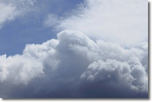
A nimbostratus cloud is similar to a stratus cloud in its formless,
smooth appearance. However, a nimbostratus cloud is darker than a stratus cloud,
because it is thicker.
Unlike a stratus cloud, a nimbostratus cloud typically brings with it the threat
of moderate to heavy precipitation. In some cases, the precipitation may evaporate
before reaching the ground, a phenomenon known as virga.
Next Topic: Precipitation
Current conditions powered by WeatherAPI.com


